


Real time global migration map created
Engineers and researchers at Facebook have used anonymous data from three billion Facebook users to create a fascinating interactive map of global migration.
The team appear to have been able to measure the long-term movement of people accurately, in near-real time, on a global scale.
Traditional methods rely on censuses or administrative records, which are often collected irregularly and inconsistently across countries.
Although some recent innovations have used mobile phone data or social media posts to create data on migration, these have been geographically limited.
The new map has side-stepped these limitations and seems to have provided a new standard for measuring human movement.
The map and its associated data reveal fascinating trends. In 2022, it estimated that 39.1 million people migrated internationally among the 181 countries included in their study.
The US led the world in net migration gains, with 3.92 million (841,200 emigrants versus 4,109,400 immigrants), while Ukraine suffered the largest net loss of 2.34 million (66,600 immigrants versus 2,402,100 emigrants).
Global migration plummeted by 64 per cent during the COVID-19 pandemic, reflecting widespread travel restrictions, before rebounding by 2022 to rates 24 per cent higher than pre-pandemic levels.
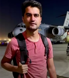
 The data also vividly captures the human consequences of humanitarian crises or conflict. Following Russia’s invasion in February 2022, emigration from Ukraine surged ten times compared to pre-war levels, with an estimated 2.3 million people settling elsewhere for at least a year by December 2022.
The primary destinations were identified as Poland, Germany, the Czech Republic, the US, and the UK – aligning closely with UNHCR figures.
Similar rises in migration were seen following Hong Kong’s passage of a draconian security laws in 2020, with migration to the UK increasing fifteenfold shortly after, and after the 2021 military coup in Myanmar.
Tracking migrants is a difficult task that policymakers, researchers and humanitarian organisations have long struggled with. The data used is often outdated, incomplete and inconsistent and this hampers efforts to understand movement and respond effectively to global crises.
The new map appears to have gone some way to solving that issue.
The team used the United Nations’ definition of migrants, including only people who settle for at least a year in a new country.
They built their estimates by first predicting each user’s home country based on signals like self-reported location and IP addresses. Then the looked at long-term changes in residence, applying an algorithm maximise alignment with standard migration definitions.
Because Facebook users are not exactly representative of the global population with more affluent people more likely to use Facebook and more likely to migrate, the researchers developed a weighting system that allows for these imbalances.
The aim was to tap into real-world migration flows rather than the vagaries of social media usage.
Unsurprisingly, the team found that migration patterns are related to economic disparities and social networks. Wealthier countries attract a larger share of migrants, while migration between neighbouring countries is far more common than between distant ones.
The real-time, high-resolution data has the potential to improve responses to disasters and urban planning.
With that in mind, the team is releasing their dataset publicly through the Humanitarian Data Exchange, ensuring broad access to future work.
See a rendering of the map here: Opinion | An Interactive Map of Global Migration – The New York Time